Infinity Earth
-
Home
-
Infinity Earth
Infinity Earth
The idea of Infinity Earth envisions our planet as part of an unbounded, multidimensional reality where familiar 3D space is just one layer of existence
Visualizing Earth Through the Lens of Higher Dimensions
Introduction
Modern geovisualization challenges us to move beyond traditional 2D maps and even conventional 3D models. By incorporating concepts from higher-dimensional mathematics, we can create more accurate and insightful representations of Earth's complex systems. This article explores how principles from multidimensional geometry can enhance our understanding of planetary structure, surface dynamics, and spatial relationships.
The Limitations of 3D Visualization
Traditional 3D Earth models face several fundamental constraints:
Information Compression - Crushing multidimensional data (tectonic stresses, atmospheric layers, temporal changes) into three spatial dimensions
Perspective Distortion - Difficulty maintaining accurate proportions across scales from crustal features to core structures
Occlusion Problems - Inability to simultaneously visualize surface topography and interior composition
These limitations mirror the challenges early cartographers faced when projecting a spherical Earth onto flat maps—we're now struggling to project higher-dimensional geodata into 3D space.
Higher-Dimensional Approaches to Earth Modeling
1. Temporal as the Fourth Dimension
Treating time as a fourth axis enables:
Dynamic crustal movement visualization
Mantle convection patterns across geological timescales
Core dynamo evolution showing magnetic field changes
2. Parameter Space as Additional Dimensions
Mapping non-spatial variables to virtual dimensions:
Seismic wave velocities (revealing subsurface composition)
Gravitational anomalies (indicating mass distribution)
Chemical gradients (showing mantle differentiation)
3. Hyperdimensional Projection Techniques
Mathematical methods adapted from theoretical physics:
Dimensional stacking - Simultaneous representation of crustal elevation and lithospheric thickness
Color-space encoding - Using hue/saturation/value to represent multiple parameters at single points
Topological folding - Creating "cutaway" views that maintain spatial relationships
Accuracy Enhancements Through Multidimensional Thinking
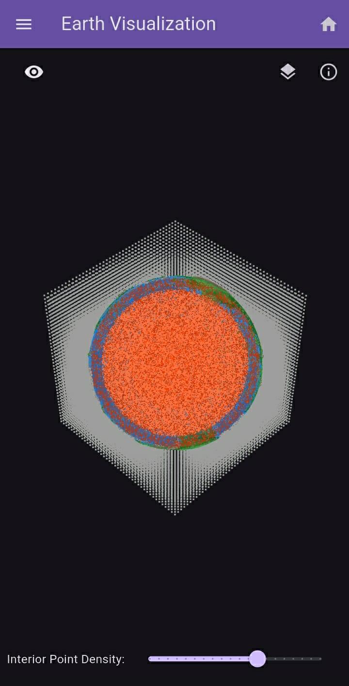
1. Density Field Representation
Traditional 3D models struggle with:
Vast scale differences between atmospheric and geologic features
Discontinuous properties at layer boundaries
Higher-dimensional approaches allow:
Variable density point clouds that accurately represent transition zones
Fractal-based distribution of interior points matching seismic data
Quantum-scale to planetary-scale representation in unified models
2. Cross-Sectional Integrity
Conventional slice views distort:
Curvature along cut planes
Layer thickness proportions
Advanced methods maintain:
Geodesic accuracy in cross-section boundaries
Dynamic re-projection as the section plane moves
Inter-layer connectivity visualization
3. Hypersurface Texturing
Beyond conventional bump mapping:
4D noise functions generating realistic tectonic patterns
Multivariate color spaces encoding elevation, composition, and age
Anisotropic reflectance models showing crystal orientations in mantle minerals
Practical Applications
1. Seismic Hazard Mapping
Multidimensional visualization enables:
Simultaneous display of fault geometry and stress accumulation
4D rupture propagation models
Subduction zone dynamics with chemical transport
2. Core-Mantle Boundary Studies
Revealing features invisible in 3D:
Ultra-low velocity zones as 4D structures
Plume conduits with time-varying chemistry
The "anti-continent" at the core-mantle boundary
3. Climate-Geosphere Interactions
Visualizing couplings between:
Ice sheet mass and crustal rebound
Ocean chemistry and seafloor weathering
Atmospheric pressure and mantle convection
Future Directions
Emerging technologies will enable:
Holographic hyperslices - Interactive 4D cross-sections
Quantum lattice representations - Atom-scale to planetary-scale modeling
Neural topology mapping - AI-generated dimensional projections
As we develop these tools, we're not just creating better visualizations—we're developing new ways of understanding planetary systems as inherently multidimensional entities. The boundary between "visualization" and "simulation" becomes increasingly porous when we embrace higher-dimensional representations.
Conclusion
The quest for accurate Earth visualization pushes us beyond conventional geometry. By embracing higher-dimensional mathematics and projection techniques, we can create representations that better match the complexity of real planetary systems. These approaches don't just make prettier pictures—they offer fundamentally new ways to analyze geophysical relationships and dynamics that remain obscured in traditional 3D models. As with Mercator's breakthrough in 1569, the next revolution in Earth visualization may come from daring to represent our world through unconventional dimensional frameworks.
Share this service: